Mahabaleshwar is a small town and a municipal council in Satara district in the Indian state of Maharashtra. It is a place of pilgrimage for Hindus because the Krishna river has its origins here The British colonial rulers developed the town as a hill station and served as the summer capital of Bombay Presidency during the British Raj.
Mahabaleshwar is located at 17.9237°N 73.6586°E. It has an average elevation of 1,353 meters (4,439 ft).
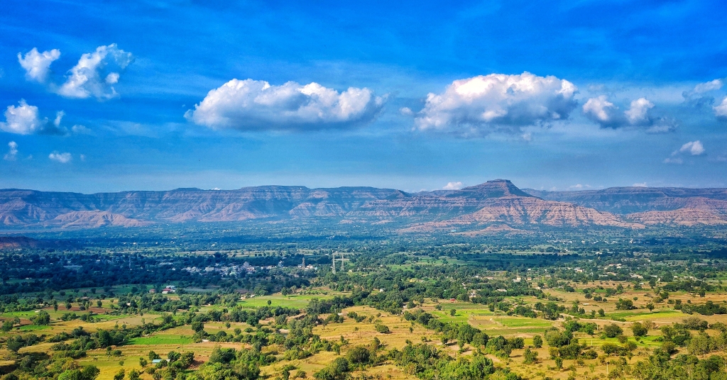
Located about 120 km (75 mi) southwest of Pune and 285 km (177 mi) from Mumbai, Mahabaleshwar is a vast plateau measuring 150 km2 (58 sq mi), bound by valleys on all sides. It reaches a height of 1,439 m (4,721 ft) at its highest peak above sea level, known as Wilson/Sunrise Point.
Mahabaleshwar comprises three villages: Malcolm Peth, Old “Kshetra” Mahabaleshwar and part of the Shindola village.
Mahabaleshwar is the source of the Krishna River that flows across Maharashtra, Karnataka, Telangana and Andhra Pradesh. The legendary source of the river is a spout from the mouth of a statue of a cow in the ancient temple of Mahadev in Old Mahabaleshwar. Legend has it that Krishna is Lord Vishnu himself as a result of a curse on the trimurtis by Savitri. Also, its tributaries Venna and Koyna are said to be Lord Shiva and Lord Brahma themselves. An interesting thing to notice is that 3 other rivers come out from the cow’s mouth apart from Krishna and they all travel some distance before merging into Krishna which flows East towards the Bay of Bengal. These rivers are the Koyna, Venna (Veni) and Gayatri. The Savitri river flows Westward via Mahad to the Arabian Sea.
The climate of the area is suitable for cultivation of strawberries, Mahabaleshwar strawberry contributes to about 85 percent of the total strawberry production in the country. It also received the geographical indication (GI) tag in 2010.
There are many tourist points and 5 temples to see, with examples of old Indian architecture. There are also natural viewpoints, some of them named by the 19th century British colonial rulers.
Krishnabai temple
Behind Panchganga temple, there is a small trail that leads to Krishnabai temple where the Krishna river is worshiped. It is built on the hilltop overlooking the Krishna valley and was built in 1888 by a ruler of Ratnagiri on the Konkancoast. The temple has a Shiva lingam and a beautiful statue of Krishna. A small stream of the river flowing from a cow-face (gomukh) falls on a ‘Kunda’ or water tank. Stone carved columns and ceilings are the special characteristics of this temple. This old temple has gathered moss and is in ruins. It is not visited much by tourists and is isolated. But it provides a most exquisite view of the river Krishna.
3 Monkey Point
Named because of the natural sculpture of the stones which looks like three monkeys sitting beside each other and portraying 3 monkeys of Gandhiji. Nestled deep in the valleys one can figure out from the outline of a big stone a natural cut out it give an effect of 3 monkey sitting next to each other portraying the Three Wise Monkeys. This point is on route to Arthur’s Seat.
Arthur point
Officer Sir Arthur Malet (1806–1888)[3](Not to be confused with British born actor of the same name), who sat here and gazed at the Savitri River, where he lost his wife and children in a tragic ferry mishap.
Venna Lake
Mahabaleshwar is a holiday resort, honeymoon spot, and a pilgrimage site for Hindus.Boats on the Venna lake in Mahabaleshwar.
The Venna lake is one of the tourist attractions of Mahabaleshwar. The lake is surrounded by trees.
There are hotels from budget hotels to 3 Stars hotels. There are hotels with the Lake’s View or in the market.
Viewpoint
Kate’s Point
Balakwadi dam viewed from Kate’s Point
Kate’s point is located to the east of Mahabaleshwar and is famous for its view of two reservoirs, Balakwadi and Dhom. The point is around 1,280 m high.
Needle Hole Point / Elephant Point
Needle hole rock, viewed from the point
Needle hole point is located near Kate’s Point. One can see a natural rock formation with a hole in between, thus giving the name Needle-hole. The point is also famous for the view of Deccan traps, which look like an elephant’s trunk.
Wilson Point
Named after Sir Leslie Wilson, the Governor of Bombay from 1923 to 1926, Wilson Point is the highest point in Mahabaleshwar at 1439 m. Known as Sindola Hill during the colonial rule, Wilson point is the only location in Mahabaleshwar where both sunrise and sunset can be seen. It offers a spectacular glance of Mahabaleshwar in all directions. It located at behind Mahabaleshwar-Medha road at 1.5 km from Mahabaleshwar city.
Pratapgad
Pratapgad is a fort near Mahabaleshwar. The fort was built by Shivaji Maharaj. It is the site of the encounter between Shivaji and Bijapur general, Afzalkhan, where the latter was defeated and killed by Shivaji Maharaj.
Lingmala Waterfalls
Panoramic view of Lingamala waterfalls
This waterfalls is located near Mahabaleshwar. The water here falls from a height of approximately 600 feet. The water of Lingamala waterfalls cascades into the Venna Lake. The waterfalls is divided by projecting rocks into multiple tier.[non sequitur]
Demographics
As of 2011 India census, Mahabaleshwar had a population of 12,737. Males constituted 55% of the population and females 45%. Mahabaleshwar had an average literacy rate of 78%, higher than the national average of 74.04%: male literacy was 84%, and female literacy was 71%. In Mahabaleshwar, 11% of the population was at that time under 6 years of age.
knowledge source : Wikipedia